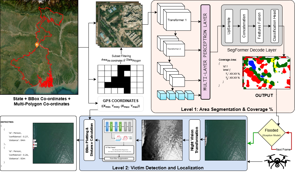
Geospatial AI · UAV · Semantic Segmentation · Thermal Imaging
Department of Computer Science and Engineering (AIML)
Heritage Institute of Technology, Kolkata
Rapid and effective disaster response remains a critical challenge, particularly during floods, where timely identification of affected areas and victims can save lives. Existing systems often rely solely on either satellite imagery or ground-based sensors, limiting their ability to quickly and accurately pinpoint flooded zones and locate stranded individuals.
To address this gap, we propose Res-GeoAI, a geospatial AI system that integrates satellite-based flood detection with drone-assisted victim identification. Our system operates in three stages: (1) flood-zone mapping using satellite images; (2) thermal imaging for detecting victims under low-visibility conditions; and (3) GPS-based coordination for rescue operations.
By combining these capabilities, Res-GeoAI enhances the speed and precision of humanitarian interventions, providing a scalable solution for disaster management.
Res-GeoAI operates through a hierarchical multimodal pipeline that bridges macro-level satellite analysis with micro-level UAV victim localization.
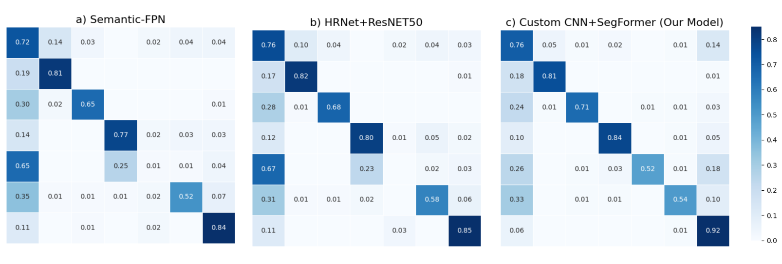
Geographic regions are tessellated into tiles. A modified SegFormer with multiscale attention performs semantic segmentation, computing per-pixel flood probability and overall coverage.
Candidate flood regions are validated via a lightweight Xception-based classifier. UAV deployment is triggered when confidence > 0.7 and flood coverage > 10%.
UAVs follow a spiral search pattern and apply night-vision transformation. VarifocalNet with IoU-aware loss detects victims; GPS coordinates are computed from bounding boxes.
| Model | Background | Building | Road | Water | Barren | Forest | Agriculture | mIoU |
|---|---|---|---|---|---|---|---|---|
| UNet | 43.46 | 60.59 | 52.35 | 69.22 | 46.60 | 24.23 | 41.88 | 48.95 |
| Semantic FPN | 60.70 | 50.92 | 51.36 | 73.93 | 52.05 | 56.24 | 76.94 | 57.98 |
| FuseNet | 47.19 | 50.77 | 61.36 | 68.21 | 31.71 | 47.71 | 57.45 | 52.62 |
| HRNet | 54.61 | 55.34 | 57.42 | 73.36 | 46.78 | 45.87 | 69.88 | 59.40 |
| Ours (CNN+SegFormer) | 60.68 | 63.25 | 62.08 | 76.47 | 47.93 | 47.82 | 72.75 | 66.30 |
| Model | Training Accuracy | Test Accuracy |
|---|---|---|
| InceptionNetV3 | 0.990 | 0.844 |
| ResNet50 | 0.974 | 0.937 |
| Xception (Ours) | 0.998 | 0.946 |
| Model | Normal RGB | Thermal | Infrared | Night Vision | ||||
|---|---|---|---|---|---|---|---|---|
| mF1 | MPR | mF1 | MPR | mF1 | MPR | mF1 | MPR | |
| YOLOv8 | 0.841 | 0.136 | 0.846 | 0.136 | 0.850 | 0.133 | 0.857 | 0.131 |
| VFNet (Ours) | 0.858 | 0.117 | 0.863 | 0.114 | 0.860 | 0.115 | 0.865 | 0.111 |
| Module | Input Size | Time | Memory | Accuracy |
|---|---|---|---|---|
| Tile Generation | 1024×1024 | 0.80s | 17.5 MB | 1.00 |
| Flood Detection | 1024×1024 | 0.05s | 4.5 MB | 0.66 |
| Flood Validation | 1024×1024 | 0.02s | 1.5 MB | 0.95 |
| Victim Detection | 512×512 | 0.04s | 2.0 MB | 0.86 |
| GPS Localization | — | 0.01s | 0.1 MB | ±3.2m |
We introduce HIT-MOB, a harmonized dual-modality UAV dataset constructed by merging the HIT-UAV thermal dataset and the MOBDrone maritime dataset into a unified 9-class schema.
kaggle.com/dsv/12184019 · DOI: 10.34740/KAGGLE/DSV/12184019
If you find this work useful, please cite:
@article{pal2025resgeoai,
title = {Res-GeoAI: A Satellite-to-Drone Dual-Modality System
for Flood Detection and Victim Localization
in Disaster Response},
author = {Pal, Anidipta},
year = {2025},
url = {https://doi.org/10.13140/RG.2.2.32814.88642}
}